Carnival Corporation cruise ships put Arctic, Subarctic marine mammals at risk, groundbreaking new map shows

Nearly half of Carnival’s ships travel near, through critical habitat for walrus, orcas, other whales while burning one of world’s dirtiest fossil fuels
Date: February 6, 2019
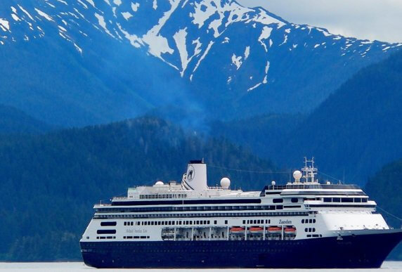
The MS Zaandam, operated by Holland America, a Carnival Corporation subsidiary, photographed with a plume near Sitka, Alaska.

SAN FRANCISCO — A groundbreaking new interactive map released today by the international Clean Up Carnival coalition shows that nearly half of Carnival Corporation cruise ships traveling through the Arctic and Subarctic pass near or through critical habitats for marine mammals including orca, walrus, and bowhead, narwhal, and beluga whales.

The map details information on ship names, ship routes, the amount of heavy fuel oil carried onboard, the amount of heavy fuel oil burned in the Arctic and Subarctic, and COand black carbon emissions for all Carnival Corporation ships that traveled from 50 degrees latitude and north in 2017. The map also shows historical data on oil spills from across the shipping sector (tankers, tugs, etc.) including vessel name, fuel type, and spill amount.

Screenshot of interactive map released by the Clean Up Carnival coalition.

The Clean Up Carnival coalition is calling on Carnival Corporation — the world’s largest cruise operator — to stop carrying and using heavy fuel oil on ships traveling to the Arctic and Subarctic. A spill of this thick, residual oil in this fragile marine environment would be nearly impossible to clean up. In addition, black carbon emissions from the combustion of heavy fuel oil accelerate sea ice melt and contribute to global sea level rise.

It is generally agreed upon that Arctic waters are 60°N latitude and above; however, the Subarctic is more loosely defined. For the purposes of this map, the Subarctic is defined as 50°N latitude and above, which encompasses Southeast Alaska and Northern British Columbia.

The British Columbia coast is home to the threatened Northern Resident Killer Whales and critically endangered Southern Resident Killer Whales. Narwhal whales and two populations of bowhead whales are currently being considered for listing under Canada’s Species at Risk Act (SARA). The Cook Inlet species of beluga whales is listed as endangered under the U.S. Endangered Species Act.

The International Maritime Organization’s (IMO) definition of the Arctic does not follow the 60°N latitude definition — it instead excludes Iceland and the Norwegian mainland. Greenland and the Norwegian archipelago Svalbard, where heavy fuel oil is already banned in most places, are within the IMO-defined Arctic.

“Carnival brands dominate cruise traffic in Southeast Alaska. They bring passengers on breathtaking journeys and offer economic opportunity to communities. But, there’s no reason to pollute local towns, and cruise passengers, by burning the world’s dirtiest fuel,” said Jim Gamble, Senior Arctic Program Officer at Pacific Environment.

“Marine ecology does not follow human-created boundaries, and unfortunately, neither does pollution. Not only could a spill of heavy fuel oil have a long-term, detrimental impact on the critical habitat of several Arctic marine mammals, but the black carbon emissions from cruise ships burning heavy fuel oil put the fragile ecosystems of the Arctic and Subarctic at serious risk,” said Kendra Ulrich, Senior Shipping Campaigner at Stand.earth.

“This map is groundbreaking and will educate and empower indigenous communities who are most affected by Carnival’s pollution in the Arctic. They have lived in the region for thousands of years, still rely on a healthy environment and abundant wildlife, and have to live with Carnival’s reckless ecological decisions. They now have a tool to monitor Carnival to help protect their livelihoods,” said Verner Wilson III, Senior Oceans Campaigner at Friends of the Earth US.

“This map shows just how many Carnival Corporation cruise ships are sailing the coastal Subarctic waters in Europe and specifically along the coast of Norway, which includes UNESCO world heritage sites. Although not defined as IMO Arctic, nonetheless these areas are sites of vulnerable ecology, nature and heritage which deserves protection,” said Dr Lucy Gilliam, Aviation & Shipping Officer at Transport & Environment.

The map findings include:

  • Of the 103 ships in Carnival’s global fleet in 2017, 49 ships — nearly 50% — operated in the Arctic and Subarctic. These ships pass near and through critical habitats for marine mammals including orca, walrus, and bowhead, narwhal, and beluga whales.

The 49 Carnival Corporation cruise ships included in the map:

  • Emitted 147 tons of black carbon in the Arctic and Subarctic in 2017. Cruise ships emit approximately three times the amount of black carbon as cargo ships.
  • Burned approximately 466,000 metric tons of heavy fuel oil in the Arctic and Subarctic in 2017. That’s enough heavy fuel oil to fill the Empire State Building halfway to the top.
  • Emitted approximately 1.5 million metric tons of COin the Arctic and Subarctic in 2017. That’s equivalent to the annual emissions of more than 300,000 cars.

Carnival Corporation is the largest cruise line operator in the world with over 40% of the global market share and ten brands that operate worldwide. Carnival Corporation brands that travel to the Arctic and Subarctic include Princess Cruises, Holland America, AIDA, P&O UK, Costa, and Cunard and Seabourn (which are both listed as “other” in the map).

Clean Up Carnival member organizations include Stand.earth (North America); Transport & Environment (Europe); Friends of the Earth (US); and Pacific Environment (North America and Asia). Lean more at https://www.cleanupcarnival.com/.